These site plans are not strictly comparable, having different drafting styles and scales. But there is value in looking at the building labels to appreciate how the Ex's focus changed. The New Fort is ignored until after it is demolished in 1953; its one surviving building, shown in 1963 as 'Marine Museum,' is drowning in a sea of PARKING.
For more information on specific extant CNE buildings, see
this virtual walking tour.
Click the maps to view full-size versions. Images courtesy Exhibition Place Archives.
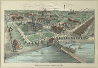
Exhibition Park Toronto, 1906. [See also
this version at the TPL]. Printed.
In October 1906 the Crystal Palace (a.k.a. the Transportation Building) burned to the ground.
Map of Grounds with Location of Buildings Looking up from Lake 1921. Printed.
Note the appearance of the '
Street Car Loop' (1916), and the slight westward expansion of the grounds.
Plan of Grounds and Buildings - Canadian National Exhibition
1928. Det. Stanley Tucker. Printed.
The Princes’ Gates were opened in 1927.
Canadian National Exhibition Plan of Grounds and Buildings. 1940. Printed.
The Horse Palace was constructed in 1931.
Map of the Canadian National Exhibition Grounds. 1953. Printed.
From 1951/53 the Stanley Barracks were demolished, save for the Officers’ Quarters! On this version of the map the structure isn’t even labeled.
Map of the Canadian National Exhibition Grounds. 1963(?). Printed.
Note: the third incarnation of the Dufferin Gates (1959). The Manufacturer’s building burned down in January 1961. Although the archival info for the map lists it as being for 1963, the absence of the Better Living Centre (opened in August 1962) indicates that the map reflects the grounds in 1961.
Your Guide to the World’s Largest Annual Exhibition. 1974. Printed.
The Alpine Way -- Don’t forget your camera!
Map: Canadian National Exhibition. 1985. Printed.
In the mid-70s Exhibition Stadium was reconfigured for the expansion Toronto Blue Jays.
CNE Site Map. 1994. Printed.
2012 Canadian National Exhibition Map. Printed.
Of interest: Ricoh Coliseum and BMO Field.
Who knows what the future shall bring for the Ex?
Next map:
1995 Archaeological Services Inc.: Composite map of the New Fort, circa 1840-1950 within the context of the CNE grounds
Back to:
The Exhibition Grounds


![1846 Gray: Toronto, C.W. Sketch shewing the Harbour, and Ordnance Property with the Encroachments... [Stanley Barracks]](http://maps.library.utoronto.ca/datapub/digital/NG/FY/1846Gray.TorontoNF.jpg "1846 Gray: Toronto, C.W. Sketch shewing the Harbour, and Ordnance Property with the Encroachments... [Stanley Barracks]")

![1846 Gray: Toronto, C.W. Sketch shewing the Harbour, and Ordnance Property with the Encroachments... [Reserve]](http://maps.library.utoronto.ca/datapub/digital/NG/FY/1846Gray.TorontoReserve.jpg "1846 Gray: Toronto, C.W. Sketch shewing the Harbour, and Ordnance Property with the Encroachments... [Reserve]")
 1833 Bonnycastle: No. 2 Plan of Comparison shewing ... the site of the new Barrack...")
 1833 Nicolls/Bonnycastle: No. 3. Plan and Sections of the New Work proposed to be erected on the Military Reserve farther to the westward for the defence of the entrance of the York Harbour")


![1898 Walker: [EAST] Plan of Part of the Military Reserve . . . applied for by Canadian Pacific Railway Company, 1](http://maps.library.utoronto.ca/datapub/digital/NG/FY/1898MilitaryReserveIMG_7294.jpg "1898 Walker: Plan of Part of the Military Reserve . . . applied for by Canadian Pacific Railway Company, 1")


 - Detail")