Welcome!

1816 Nicolls/Duberger Plan of Fort at York, Upper Canada, shewing its state in March 1816
Plan of Fort at York, Upper Canada,
shewing its state in March 1816

Image courtesy Library and Archives Canada
This collection of captioned historical maps explores the complex evolution in use and ownership which has transpired within the area comprising Fort York, and the surrounding Garrison Common.

Each chapter takes you through a series of maps that tell the story of the corresponding subject or area. Click on any map or graphic to view it full-size, in a separate window.


Read: About Maps by Joan Winearls
Start your exploration: The Military Reserve
Sitemap: Complete Map List
More: About this Project

2014 DTAH: Fort York Parks and Open Space Network

It may not come naturally to think of the approximately 100-acre open-space corridor between Strachan and Bathurst, north from Coronation Park through Fort York and Stanley Park to the gates of Trinity Bellwoods Park, as a system of green stepping stones through the city, but this condition is emerging. Understanding our downtown open spaces as green pathways through a grid of buildings and flanking streets, and now including the significant 7.4-acre area added in August 2014 when Toronto City Council redesignated the “Employment Areas” south of Wellington Street West between the Destructor and Strachan House, is to broaden our understanding of what Toronto is and may be. This Open Space Network plan is a major step forward in capturing the potential for sustained city-building that can take place over the next decade.

Click the map to view a full size version (Note: The map is quite large in area; you may need to use your browser’s zoom or scrolling controls).

Map: 2014 Fort York Parks and Open Space Network. Prepared by DTAH for the Friends of Fort York

Fort York Parks and Open Space Network
Prepared for the Friends of Fort York by DTAH, Nov. 2014.
Image courtesy of Friends of Fort York.


Next Chapter: The ‘New’ Fort (Stanley Barracks)
Back to: ‘Old’ Fort York

1797 Bouchette: Plan of York Harbour

This map, engraved for publication in 1815, is based upon Bouchette’s 1792 manuscript map of Toronto harbour. But it has been updated to include information known to the end of the 18th century. For example, it shows the blockhouse of 1797 on the east side of Garrison Creek, though maybe not Government House of 1800 on the west side. While it’s hardly surprising the map is weak in depicting features where Bouchette lacked special knowledge, such as the town plot and the mouth of the Don, it provides information not found elsewhere, about things he knew intimately. These include Fort York and the raising of H.M.S. Schooner Anandaga [sic] in 1794, for which he was promoted to Second Lieutenant though barely twenty years old.

Bouchette was more familiar with Toronto harbour than anyone else at that time. When Governor and Mrs. Simcoe traveled to Toronto aboard the Mississaga on 29 July 1793 to establish Fort York and found the town, he was at the ship’s helm to bring it into harbour safely. Later he would draw this map, and later still produce a sketch of Fort York to decorate the border of a map found in the U.S. National Archives.

Here he shows crescent-shaped earthworks west and south of Fort York, the latter where the Government House bastion and its successor, the present-day semi-circular bastion, were located. Within the fort, a long feature parallel to the shore presumably was meant to indicate barracks. The Military Reserve and road along the lake are drawn clearly.

Click the map to view a full size version.


Plan of York Harbour by Josh. Bouchette
Published by W. Faden Charing Cross Augst 12th 1815. J. Walker Sculpt.
via Joseph Bouchette, A Topographical Description of the Province of Lower Canada, oppp605 (London: W. Faden, 1815)
Image courtesy Toronto Public Library: T1815/fold
Winearls, MUC no. 2013 (4)


Next map: 1813 Williams: Sketch of the ground in advance of and including York Upper Canada & 1814 Williams: Plan of the Town and Harbour of York
Back to: ‘Old’ Fort York

2012 Stewart: Fort York National Historic Site showing The Encampment

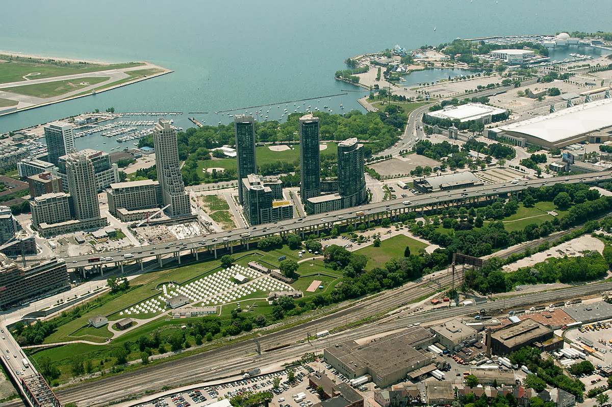
In 2012 Fort York hosted The Encampment, a large-scale public participatory art installation commissioned by Luminato and City of Toronto, for the War of 1812 Commemoration. Executed under the direction of Thom Sokoloski and Jenny Anne McCowan, the installation “proposes the archaeological encampment as its metaphor. A dig for artifacts is replaced by a dig into the collective memory of a public space and its history.”

Some 200 tents housed separate art displays inspired by individuals living in the Canadas from the War of 1812, evoking the stories of “an assemblage of peoples including First Nations, European immigrants, African Canadians, as well as European and Native loyalists expelled from the United States after the American Revolution.” The installations were implemented by a team of approximately 100 interdisciplinary artists and creative collaborators. During the 17-day exhibition period, including evenings, when the installation was open to the public some 10,000 visitors came out specially to see it.

Click the photo to view a full size version.

Aerial photo of The Encampment at Fort York, for Luminato 2012

Aerial view of Fort York National Historic Site, looking south, showing The Encampment (a project of Luminato Festival), June 2012.
Photo by Tim Stewart. Image courtesy The Fort York Foundation

The programme for The Encampment may be examined here.

Bonus
The Encampment - 2012 documentary produced by Regent Park Film School + Luminato


Next map: Contemporary Satellite & Aerial Imagery
Back to: Aerial Photographs

1994 Waterfront Regeneration Trust: Fort York and Surrounding Neighbourhood

This view of Fort York taken from the CN Tower is what the area looked like in 1994 when the Friends of Fort York, one of the collaborators in this website, was established to advocate the fort’s best interests. In the foreground the lands east of Bathurst still bear the scars of the rail tracks that were there before.

Molson’s Brewery and St. Mary’s Cement dominate the area south of the Gardiner Expressway. Fort York Boulevard had not yet been built, but the heavily-polluted site at 28 Bathurst Street was finally being cleaned up (note the blue plastic tarps).

Click the photo to view a full size version.

Aerial photograph of Fort York & Surrounding neighbourhood circa 1994

Fort York & surrounding neighbourhood, 1994
Photo courtesy of the Waterfront Regeneration Trust, Toronto


Next map: 2012 Stewart: Fort York National Historic Site showing The Encampment 
Back to: Aerial Photographs

1919 Canadian Postcard Company: Canadian National Exhibition from the Air

In looking at these aerial views taken from a biplane (note the wing intruding into the images on the left) one is reminded of Dr. Johnson’s aphorism having to do with a different subject: “It is not done well; but you are surprised to find it done at all.” The Canadian Postcard Company was an active pioneer in taking views of Canadian towns and cities from the air following World War One. To secure copyright protection for these pictures as they were turned into postcards, it registered the images with the Canadian Government and the British Museum, guaranteeing their survival in one place or another.

Among the several aerial pictures of the CNE only a few show the Stanley Barracks amidst the chaos of other buildings and the midway.

[Additional Toronto photographs from the same series here]

Click the image to view a full size version.


Canadian National Exhibition from the Air, 1919 (HS85-10-36082)
Published by the Canadian Postcard Company
Courtesy British Library: Canadian Copyright Collection, HS85-10-36082
[Patent and Copyright Office, Library and Archives Canada]

Click the image to view a full size version.


Canadian National Exhibition from the Air, 1919 (HS85-10-36083)
Published by the Canadian Postcard Company
Courtesy British Library: Canadian Copyright Collection, HS85-10-36083
[Patent and Copyright Office, Library and Archives Canada]

Bonus image:
1919 CNE Poster
via Library of Congress:
cph 3g12163


Next map: 1926 Fairchild: Aerial Views of Fort York and Clarence Square
Back to: Aerial Photographs

1954/55: Lakeshore Blvd. West at Bathurst Street

This intersection did not exist until 1929 when Bathurst Street (which previously ended at Front Street) was extended to intersect with Lakeshore Blvd. W., itself a product of waterfront landfill and improvement schemes in the 1920s. It did not take long for several showcase buildings and structures to be erected near or at the intersection, attracted by its cachet: Maple Leaf Stadium (1926); The Princes’ Gates (1927); Crosse & Blackwell’s Building [hexagonal structure] (1927); Loblaws Warehouse (1928); Tip Top Tailors factory (1929) and Rogers-Majestic’s radio factory [NW corner] (1929). This photo can be dated to 1954/55 from the progress being made in constructing Molson’s Fleet Street Brewery, seen in scaffolding. Part of the land for it was purchased from E.P. Taylor’s Canadian Breweries, necessarily by an intermediary because Taylor would never have sold knowingly to a competitor.

Click the image to view a full size version. For more on this photo, see this piece in Spacing by Adam Bunch.


Lakeshore Blvd. West at Bathurst Street, 1954/55

The same corner, perhaps a few years earlier, viewed from the west:


Image courtesy City of Toronto Archives, William James family fonds, Fonds 1244, Item 7297


Next map: [1957, 1962, 1971, 1983, 1992] Aerial Photographs
Back to: Aerial Photographs

1846 Howard: Chart of the North Shore of Toronto Harbour and Plan of the Wharves and Storehouses, &c &c

What a lot of information John Howard, who was both a surveyor and an architect, crammed on this one sheet, sometimes where it is least expected. In the upper left corner are profiles of the end of the Queen's Wharf in Jan. 1835 and May 1846 as well as soundings in the fishing grounds off the Gibraltar Point lighthouse. In the upper right corner he shows the profiles of the bank along Lake Ontario between Portland and Bay Streets, and also a cross-section of the Government [Garrison] Creek ravine where a small bridge crosses it.

But the real business of the map is to show information on all the piers across the front of the City behind the Windmill Line running from Gooderham’s mill-tower in the east to the old French fort in the west. Until it was replaced by a new Windmill Line in 1893 this line defined how far into the harbour wharves could extend.

Click the map to view a full size version.


Chart of the North Shore of Toronto Harbour, and Plan of the Wharves and Storehouses, &c &c
Surveyed by Mr John G. Howard D.P. Surveyor, Toronto 1846. [Sgd] John G. Howard Surveyor August 17th 1846.

Source: Ontario Ministry of Natural Resources, Office of the Surveyor General. SR 410 H24
© 2013 Queens Printer Ontario
Winearls, MUC no. 2079 (1)

–––

The same day as John Howard recorded the information on the harbour in the plan above, he also imagined a new waterfront where shipping would tie up in one- or two-boat ‘bays’ along a mile-long esplanade extending from near Gooderham’s mill to the Queens’s Wharf.  The water’s edge would be defined by a 150-foot wide cribbed structure holding back fill used to create several acres of new land. Two alternate designs for the embayment are shown too.

Although Howard would not have known its importance, he has left us here a clear understanding of the layout of the Market Block in the brief window between the completion in 1845 of the Second City Hall (now the Market Gallery), and the fire that in 1849 destroyed the market square where St. Lawrence Hall and the north market now stand.

Click the map to view a full size version.


Toronto Harbour 
[Sgd] John G. Howard D.P. Surveyor August 17th 1846

Source: Ontario Ministry of Natural Resources, Office of the Surveyor General. SR 6477 P10-22
© 2013 Queens Printer Ontario
Winearls, MUC no. 2079 (2)


Next map: 1851 Gordon: Toronto Plan to Accompany the Returns called for by Board’s Order
Back to: Wharves and Waterfront

[1957, 1962, 1971, 1983, 1992] Aerial Photographs

These recently released aerial photos document Fort York and the Garrison Common over a 35 year period at roughly 10 year intervals. Eagle-eyed inspectors will discover a myriad of changes and detail by comparing years.

Images courtesy City of Toronto Archives. Access the Archives’ complete set of aerial maps for the city: here.

Click the images for a larger view. Hint for full size mode: The upper right navigation thumbnail can be moved (drag it to the bottom of the screen to hide it).

1957

Series 12, File 1957, Item 149

Series 12, File 1957, Item 150

1962

Note in Item 27, the Gardiner Expressway, under construction.

Series 12, File 1962, Item 43

Series 12, File 1962, Item 44

Series 12, File 1962, Item 27

1971

Series 12, File 1971, Item 28

Series 12, File 1971, Item 29

1983

Series 12, File 1983, Item 49g

Series 12, File 1983, Item 50g

1992

Series 12, File 1992, Item 49g

Series 12, File 1992, Item 50g


Next map: 1994 Waterfront Regeneration Trust: Fort York and Surrounding Neighbourhood
Back to: Aerial Photographs

1834 HWJ Bonnycastle/Tazewell: City of Toronto

The incorporation of the City of Toronto on 6 March 1834 inspired two remarkable maps of the city, one by H.W.J. Bonnycastle shown here and a second by Alpheus Todd.

Bonnycastle was a son of Capt. Richard Bonnycastle who was instrumental in planning the subdivision of the Military Reserve east of Garrison Creek. He may have worked briefly in the office of the Commissioner of Crown Lands. The Patriot [Toronto], 11 April 1834, reported that his plan of Toronto was about to be lithographed by ‘Tazewell.’

Samuel Oliver Tazewell was the first person in York [Toronto] to undertake lithography. He arrived from Kingston in 1832 and began producing maps of townships in Simcoe County then being opened for settlement. Later he did a few pictorial views. In the face of opposition from key government officials and unable to make a go of it, he quit and left the city. Bonnycastle’s map besides being the first one made of the new City may have been the last one Tazewell printed.

Capt. Bonnycastle had been very supportive of Tazewell's work, and his hand can be seen behind his son's venture into map-making. Undoubtedly the latter had access to the latest proposals for the subdivision of lands  between Peter Street and Garrison Creek, yet the layout he shows is very different from what was approved in 1837. For one, Spadina Avenue ends at Queen, and the pattern of streets and lots between there and Lake Ontario is heavily influenced by lands owned by the Hon. John Dunn and Capt. James Fitzgibbon as well as by a site for a new Government House. For another, Market [now Wellington] Street divides Victoria Square into two unequal parts; the old military burying ground and a proposed church share the smaller half. What became McDonell [Portugal] Square is shown as a burial ground, whereas only a small portion of it was then being used on a temporary basis to bury cholera victims.

A report that Todd’s map had been published appeared in the Colonial Advocate [Toronto], 22 May 1834. That map can be seen here.

Click the map to view a full size version.


CITY of TORONTO: The Capital of Upper Canada 1834
Respectfully dedicated to HIS EXCELLENCY SIR JOHN COLBORNE K.C.B. &c &c &c
H.W.J. Bonnycastle and Lithographed by S.O. Tazewell

Courtesy of the Royal Ontario Museum, © ROM
[955.87.2: : Tazewell map of Toronto, 1834. Lithograph on paper. Map by H.W.J. Bonnycastle]
Winearls, MUC no. 2066


Next map: 1836 Bonnycastle/Nicolls: Copy of Final Approved Plan By Command — Government House Reserve
Back to: East of Garrison Creek

1856 Dennis: Plan of the Subdivision of Lots 14 & 15 Wellington Place and 5 Ontario Terrace of Section A in the Original Survey of the Garrison Reserve at Toronto [Draper St.]

The following plan by J. Stoughton Dennis shows his original survey laying out what would become Draper Street, as registered by landowners William George Draper (son of the Hon. William Henry Draper) and Charles Jones.

Developed in several phases from 1881 to 1889, the intimate Second Empire-styled row cottages which line Draper Street were all designated as heritage properties by the City of Toronto in the 1990s. Of note is the relatively narrow width of the street—32 feet (just a little under half a surveyor’s chain).

An overview of the development of Draper Street may be found here (PDF; see p.6).

Click the map to view a full size version.


Plan of the Subdivision of Lots 14 & 15 Wellington Place and 5 Ontario Terrace of Section A in the Original Survey of the Garrison Reserve at Toronto. July 15, 1856.
Certified correct from Survey: J. Stoughton Dennis, P.L.S.
[Signatures] W[illiam] Geo[rge] Draper, Owner of lot no. five; Charles Jones owner of Lots fourteen and fifteen

Courtesy Ministry of Government Services, Toronto Land Registry Office: R.P. 171
Winearls, MUC no. B2531


Next map: 1884 Unwin, Browne & Sankey: Plan of the old Military Burying Ground Victoria Square, Toronto
Back to: East of Garrison Creek

1945 Toronto Terminals Railway: Toronto Viaduct - Plan of Trackage between Don Station & Bathurst Jct AS CONSTRUCTED

photo: aerial of Toronto waterfront railway trackage in early 1950s
Aerial of trackage in 1951. Photograph
courtesy of the Canada Science and
Technology Museum, Ottawa: CN002868
This very large and detailed plan—the original is perhaps twenty feet long—shows the network of railways across the front of Toronto when it was very near at its zenith, just as the Second World War was coming to a close. Canada's railways had been the sinews of industry during the conflict and, with gas-rationing in force, were essential to personal travel.

Even today, although the area has been largely redeveloped for residential and commercial uses, the imprints of some of the sidings and spur-lines shown here appear throughout the area as 'ghost corridors' and odd-shaped buildings.

Experimental zoomable view


If the above doesn't work for you, click the map image below to view a full size version of the entire plan.
[WARNING: This is a large file and may take awhile to load!]


Toronto Terminals Railway | Toronto Viaduct | Plan of Trackage between Don Station and Bathurst Junction. As constructed. Toronto: 6 February 1945, Scale 1 inch = 100 feet. 26/56
Courtesy of Toronto Terminals Railway. With files from David Dennis and DTAH.

Compare to: 1913 Map of Toronto Viaduct [Old Time Trains]


Next Chapter: Liberty Village
Back to:  The Railways

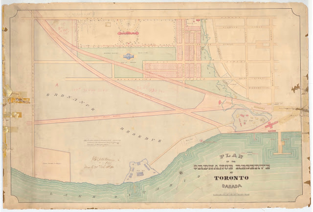
1862 Dennis: Plan of the Ordnance Reserve at Toronto Canada

This plan is remarkable not only for its lovely shaded depiction of Lake Ontario, but also for including the 1858 Crystal Palace south of the Asylum; for showing the new streets and plan of subdivision west of the Garrison Creek ravine; and for the double footprint for the Officers’ Barracks within the new fort. This last feature has left experts familiar with the building stumped, but may be explained some day by a lucky researcher who comes across a revealing report while looking for something else.

Click the map to view a full-size version (PDF).

Map: Plan of the Ordnance Reserve at Toronto Canada, 1862, by J. Stoughton Dennis

Plan of the Ordnance Reserve at Toronto Canada 
[Sgd] J. Stoughton Dennis P.L.S. Toronto 28th Feb. 1862. Owen Jones Del / 62

Source: Ontario Ministry of Natural Resources, Office of the Surveyor General: SR5904 O8-25
Copyright:  2013 Queens Printer Ontario
Winearls, MUC no. 2122(5)


Next Chapter: ‘Old’ Fort York
Back to: The Military Reserve

1827 Walpole & Phillpotts: Sketch of the Military Reserve at York shewing the position [...] of the Government Buildings

For once, the title on this map says it all: the focus of interest here is at the east end of the Military Reserve where it abuts the Town of York at Peter Street. It shows that several military buildings stand outside the Reserve on the shore above Lake Ontario where they encroached on the 30-acre strip along the water set aside in 1818 “for a Public Walk or Mall in front of the said town.” Toronto’s Union Station stands today on the last small piece of this Walks & Gardens reservation that has not been sold off or alienated otherwise.

Click the map to view a full size version.


Sketch of the Military Reserve at York shewing the position of such of the Government Buildings &c. as are situated at the dist. of several hundred yards from the Fort. 
[Sgd] J. Walpole, Lieut. Roy. Eng. R. Engrs, Office, York, March 31, 1827. George Phillpotts, Capt. Com'g. R.Engrs., West Dist.
Image courtesy Library and Archives Canada: NMC 4445
Winearls, MUC No. 2055


Next map: 1833 Bonnycastle: No. 1 Plan of the Town and Harbour of York
Back to: The Military Reserve

1827 Phillpotts, Durnford & Wright: Plan of a Pentagonal Fort containing a casemated Fortified Barrack for 200 Men proposed to be constructed at York U.C.

Planning for the new fort began over a dozen years before its erection in 1840-41. As conceived initially, it was to replace the fort of 1813-16 built at the mouth of Garrison Creek. This approach is reflected in the following proposal which shows a pentagonal fortification covering that entire site and requiring the demolition of the earlier fort. It was based upon Fort Wellington near Ostend on the recommendation of Sir James Carmichael Smyth, a Royal Engineer and trusted advisor to the Duke of Wellington who was Master-General of the Ordnance following the Napoleonic Wars. It depended upon filling in the Garrison Creek ravine and diverting the creek’s waters through the fort via pipes and sluices to flush its wastes. Apart from the staggering cost of constructing this proposal, it does not fully address the problem that York was essentially indefensible, or that following the War of 1812, bettering relations between Canada and the U.S. made a return to war unlikely.

Click the map to view a full size version.


Plan of a Pentagonal Fort containing a casemated Fortified Barrack for 200 Men proposed to be constructed at York, U.C.
[Sgd] George Phillpotts, Capt. R. Engrs. J.R. Wright, Lt. Col. Rl. Engineers Office, Quebec 20th Novr. 1827. E.W. Durnford, Col. Comg. Rl. Engineers Canada.

Image courtesy Library and Archives Canada: NMC23140


Next map: 1833 Bonnycastle: No. 2 Plan of Comparison [shewing ... the site of the new Barrack...]
Back to: The ‘New’ Fort (Stanley Barracks)

1831 Chewett: Plan of Survey of the Lands for Lease adjacent to the York Garrison in the Township of York Home District

This plan was made when the Lieutenant-Governor was still awaiting his superiors’ decision on whether a large part of the Garrison Reserve would be leased or sold to raise funds for a new fort. The matter was settled in favour of selling lots in 1833, but then was limited to the area east of the Garrison Creek. What James Chewett shows here is the subdivision of a much larger area of the Reserve, east of the Creek but also north of King Street extended, and west of a line established by present-day Shaw Street. A road allowance is proposed along the shore of the Lake Ontario. He located only two of the four public spaces in the area east of the Creek—Victoria Memorial and West Market Squares; McDonell and Clarence Squares would emerge later in Bonnycastle’s plans of 1833-37.

Click the map to view a full size version.

Map: 1831 Plan of Survey of the Lands for Lease adjacent to the York Garrison in the Township of York Home District, by James G. Chewett

Plan of Survey of the Lands for Lease to the York Garrison in the Township of York Home District
York 25th May 1831 [Sgd] J Chewett Surveyor

Source: Ontario Ministry of Natural Resources, Office of the Surveyor General. SR6074 O14-20
© 2013 Queens Printer Ontario
Winearls, MUC no. 2061


Next map: 1833 Bonnycastle: No. 2 Plan of Comparison shewing ... the site of the new Barrack ... means shall be furnished from the Sale of that part of the Military Reserve given up for the improvement of the Town
Back to: East of Garrison Creek

1853 Pilkington: Toronto. Rough Sketch showing tinted Green the portion of the Military Reserve leased to the Corporation [...]

When in 1851 the Board of Ordnance demanded the City surrender its lease on 287 acres intended for a Western Park only three years into a 999-year lease (see previous), City Council negotiated to take a smaller area. But the Board asked terms far from Council's liking involving payments to pensioners who might have settled there; it is unclear whether any lease on the subject area in green was ever executed. Instead, in 1858 after ownership of the Military Reserve had passed from the Board of Ordnance to the Provincial Government, the City was given a parcel south of the Lunatic Asylum, where Toronto’s first Crystal Palace was erected for the Provincial Exhibition held that year.

Click the map to view a full size version.

MAP: 1853 sketch by R.I. Pilkington of the Military Reserve by Fort York indicating lands leased to the city

Toronto. Rough Sketch showing tinted Green the portion of the Military Reserve leased to the Corporation, which they may retain exclusive of the Railways on the same terms as their present Lease, and the Corporation to be considered only as Yearly Tenants for the Ravine tinted Yellow
[Sgd] R.I. Pilkington, Draftsman, 28 March, 1853.
Image courtesy Library and Archives Canada: NMC4474


Next map: 1856: Dennis & Boulton: Plan of the Proposed Improvements on part of the Ordnance Reserve Toronto
Back to: The Military Reserve

1889 Hering & Gray: Plan of the City of Toronto, Proposed Intercepting Sewers and Outfall

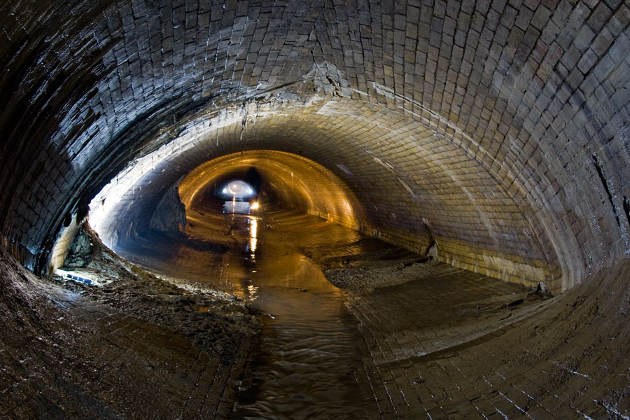
Photo: Garrison Creek Sewer - underpass beneath rail corridor immediately north-west of Fort York, by Michael Cook
Garrison Creek Sewer - Underpass beneath the rail
corridor immediately north-west of Fort York
Image courtesy Michael Cook
Increasing development and industrial use over the years unfortunately led to severe deterioration of Garrison Creek’s purity. By the early 1880s, calls were made for the polluted Creek and its ravine to be buried. Its transformation into a sewer was one of the first large-scale municipal infrastructural projects in Toronto, attendant with scandals and allegations — reminiscent of certain contemporary shenanigans — regarding its management, construction and financial beneficiaries.

The following detailed map was created by the City Engineer’s Office and used by the former City of Toronto Public Works Department to illustrate: the layout of proposed intercepting sewers and outfalls (shown in red, with arrows to indicate flow); existing drainage areas and sewage outlets (in blue); and the relationship of this sewer network to Lake Ontario and nearby lakes and rivers.

By the time this map was drawn, Garrison Creek was covered up to roughly Bloor Street. A detailed (and literal) exploration of the Garrison Creek’s colourful interment may be found via Michael Cook’s Vanishing Point project: Burying the Garrison Creek: A History. As it turned out, it would take over two decades to properly implement the City’s plan to build the proposed interceptor lines.

Click the map to view a full size version.

Map: 1889 Hering & Gray: Proposed Intercepting Sewers and Outfall - Toronto

1889 Plan of the City of Toronto, Proposed Intercepting Sewers and Outfall
Hering, Rudolph G. & Gray, Samuel M., Consulting Engineers, February 1889
City Engineers Office Toronto, March 6, 1889
Printed by Copp Clark Co. Ltd.

Image courtesy City of Toronto Archives: Fonds 200, Series 725, File 13 - MT98 (CRC172)


Supplementary Map: 1956 Garrison Creek Sewer System
In this 1956 plan of 'Existing Conditions' accompanying a report on the Garrison Creek Sewer System, the curves of the original ravine sewer form a contrast to the straight lines and angles of the rest of the system to which it connects (for orientation, the waterfront is depicted to the left).

The original sewer section running south of Wellington (delineated as an arc of blue on this map) was the handiwork of Alan J. Browne — who was also commissioned to cover over Taddle Creek. Browne’s yellow-bricked opus mostly continues to exist in good condition to this day, serving the system as an overflow channel after the 1910 installation of the High-Level Interceptor line.

Click the map to view a full size version.


Plan to Accompany Report on Garrison Creek Sewer System: Existing Conditions
[Sgd] John W. Argo, Gore & Storrie Limited Consulting Engineers, Toronto. October 5th, 1956
City of Toronto Works Department Sewer Section

Image courtesy City of Toronto Archives: Fonds 2, Series 60, Item 877

For a broader history of the Creek, see here.


Next map: 1923 City Parks Dept: Plan [of] Clarence Square
Back to: East of Garrison Creek

Contemporary Satellite and Aerial Imagery

The advent of Google maps and similar online digital services has transformed the way that we interact with mapping data. Access to such detailed imagery was previously only available in paper form at some cost or inconvenience; now anyone with an internet connection can easily view a wealth of satellite or airplane perspectives, zoom in on details, and pan around to consider the larger context. Street labels can be turned on or off for ease of identification.

Today Fort York is an urban oasis, surrounded on all sides by the frenetic city it once guarded. Development in the former lands occupied by the Military Reserve continues apace, but the Fort itself remains as a witness to Canada’s military history and the evolution of Toronto.
Google Maps – Satellite View

Click View Larger Map to view in full screen mode. Drag the mouse around to pan the view.


View Larger Map

Image courtesy Google, DigitalGlobe, First Base Solutions

Bing Maps - Bird’s Eye View

An intriguing feature offered by the Bing mapping service is the bird’s eye oblique views, which may be rotated (in addition to the regular zooming and panning) such that N, E, S, or W is ‘up’, offering novel perspectives.

Click on the image to view and interact with the map.


Image courtesy Microsoft Corporation & MDA Geospatial Services Inc.


Next map: You’ve reached the end! Read about this project or tell us what you think.
Back to: Aerial Photographs

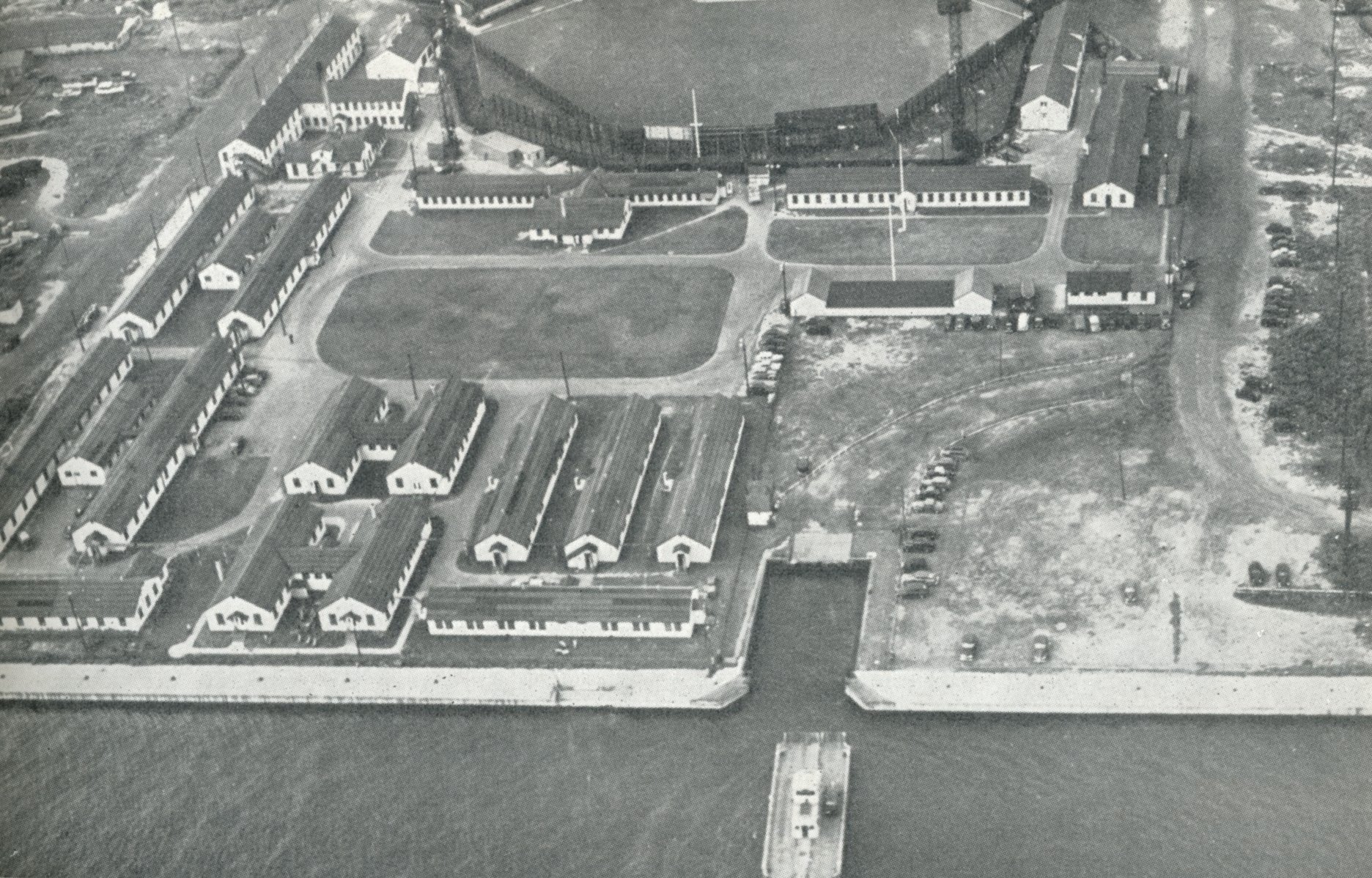
1940 Tvedte: Camp Little Norway

Little Norway," circa 1940
via Archives of Ontario/C-109-2-0-18
In April, 1940 Norway was invaded by German forces; three months later its King and government fled to exile in London. In an impressive show of resolve, by late September that same year they had made an agreement with the Toronto Harbour Commissioners to build a training base for Norwegian airmen on a site at the foot of Bathurst St., Toronto, opposite the island airport.

Seventeen buildings including barracks, messes, classrooms, a hospital and recreation hall were included there. With a capacity for 500 men, it opened in mid-November 1940. In April, 1943 the operations of ‘Little Norway’ moved to a much larger property near Gravenhurst, Muskoka, at which time its Toronto facility was purchased by the Royal Canadian Air Force. By late 1944 the buildings at ‘Little Norway’ had been turned over to the City for public housing and continued in that role until 1956. They were demolished early in the following year.

Click the image to view a full size version.


Camp Little Norway, Toronto, ca. 1940. 
from Jon Tvedte: Flyvningen. Det moderne eventyr (Oslo, 1958)
Image courtesy Wikipedia.org: Little Norway

Click the map to view a full-size version.


Insurance Plan of the City of Toronto Volume 1, Plan Dated July 1954 — Plate 74-3
Underwriters’ Survey Bureau, Ltd.


Image courtesy Toronto Public Library: 912.13681 I56 NO. 42 V. 1 AND 4

A commemorative historical plaque now marks the site of the camp.


Next Chapter: The Railways
Back to: Wharves and Waterfront