 |
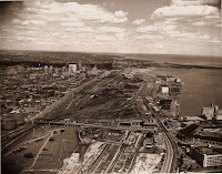
| Aerial of trackage in 1951. Photograph courtesy of the Canada Science and Technology Museum, Ottawa: CN002868 |
Even today, although the area has been largely redeveloped for residential and commercial uses, the imprints of some of the sidings and spur-lines shown here appear throughout the area as 'ghost corridors' and odd-shaped buildings.
Experimental zoomable view
If the above doesn't work for you, click the map image below to view a full size version of the entire plan.
[WARNING: This is a large file and may take awhile to load!]
Toronto Terminals Railway | Toronto Viaduct | Plan of Trackage between Don Station and Bathurst Junction. As constructed. Toronto: 6 February 1945, Scale 1 inch = 100 feet. 26/56
Courtesy of Toronto Terminals Railway. With files from David Dennis and DTAH.
Compare to: 1913 Map of Toronto Viaduct [Old Time Trains]
Next Chapter: Liberty Village
Back to: The Railways

