 |
| Victoria Memorial Park in 1913. Grave markers are visible along the back fence. Image courtesy City of Toronto Archives, Fonds 200, Series 372, Subseries 52, Item 192. |
This plan was prepared as part of the committee's report. Only a partial key to the numbered graves survives (see below). The number of burials before the cemetery was closed in 1862 is unknown, but is estimated at 400-500. For more on the burial ground, see here.
Click the map to view a full size version.
Plan of the Old Military Burying Ground Victoria Square, Toronto, 1884
by Unwin, Browne & Sankey.
Image courtesy City of Toronto Archives, Fonds 200, Series 1115, File 11
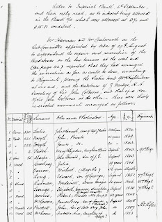
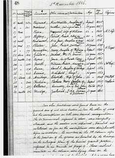
The two-page listing of known plots in the cemetery plan was made two years later, in 1886, after the Military Cemetery Committee had done as much as it was able to reconstruct the burying plan and inscriptions. Thirty markers of some sort had survived. Today, a century and a quarter later, just 17 gravestones survive, only a dozen of which can be identified. See here for more.
Click images to view full-size:
Any volunteer transcriptions of the above would be welcome.
Genealogists may wish to cross-check the above with OGS (search cemetery ID 5852).
This next rough sketch, found among the papers of the Military Cemetery Committee, was drawn in 1886 by the Rev. Alexander Williams of St. John's Garrison Church for a meeting in the Mayor's office. It is less valuable for its strict accuracy than for showing the shape of things to come as the square was reduced to its present configuration. Parcels B, C and D were tabbed for an extension of Wellington Street West. Parcels E and G having valuable frontage on Bathurst Street would go for private development. Parcel F owned by by St. John's Church was finally sold off in the 1960s. After serving as a parking lot for forty years, it was developed for a rental apartment building in 2005. Only the dead in the cemetery may have saved the park from suffering the same fate.
Click image to view full-size:
Plan by Rev. Alexander Williams.
Key to burials and Williams plan images courtesy City of Toronto Archives, RG 251, Box 1.
Next map: 1889 Hering & Gray: Plan of the City of Toronto, Proposed Intercepting Sewers and Outfall
Back to: East of Garrison Creek


