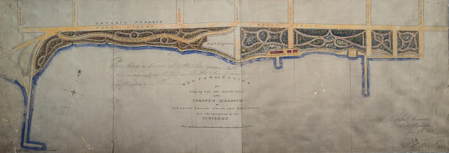
Someone has written in pencil on the face of the plan “This design seems altogether too ornamental and inconsistent therefore with the idea for an Esplanade or Promenade.” Whether this was Howard’s view or not, we don’t know. In any event by July 5, 1852—Library & Archives Canada provides the date—he had prepared a very different sort of plan (see 2nd map below). The pleasure drives and walks were still there, but they were back from the water behind a new Esplanade to which the railway(s) would have direct access. While the Esplanade would not be built until 1854-5, and then to a different configuration to what Howard shows, the rush to fill in and wall off the Toronto waterfront was on.
Click the map to view a full-size version.
Sketch of a Design for Laying Out the North Shore of the Toronto Harbour in Pleasure Drives Walks and Shrubbery For the recreation of the Citizens [Sgd] John G. Howard City Surveyor June 18, 1852. C.L.O. 29 Nov 1852
Image courtesy Toronto Public Library: MsX.1921.6. LAC: NMC 4974
Winearls, MUC no. 2094 (1)
Click the map to view a full-size version (pdf).
[Western Detail from:] Sketch of a Design for Laying Out the North Shore of the Toronto Harbour in Pleasure Drives Walks and Shrubbery for the recreation of the Citizens [Sgd] John G. Howard City Surveyor, July 5, 1852
Image courtesy Library and Archives Canada: NMC11447k_a1
Winearls, MUC no. 2094 (2)
Winearls, MUC no. 2094 (2)
[See also: Eastern half of this plan]
Next map: 1853 Scobie: General Plan of Arrangements for Railway Termini for the City of Toronto with Provision for Public Walks
Back to: Wharves and Waterfront


