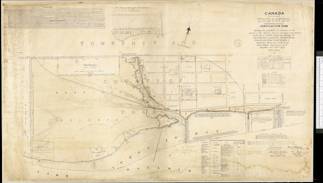
Big differences exist between this and the preceding plan, drawn by Fleming only a year earlier. The Ontario, Simcoe and Lake Huron (OS&H) Railroad has been built over the Reserve from the Queen's Wharf to intersect Queen (formerly Lot) Street east of Dufferin. A strip along the lakeshore east of the Queen's Wharf designated as 'Reserved for the Public as a Promenade' will shortly be taken over by the OS&H for its depot and yards. Elsewhere parkland is under attack too: the broken line of the proposed 287-acre Western Park leased to the City for 999 years in 1848 now describes the “Southerly Limit of the Ground Proposed to be Allowed to Pensioners.”
Click the map to view a full size version. [Note: PDF]
Canada Toronto Verification Plan shewing the Boundaries as marked on the ground of the Military Reserves belonging to the Ordnance in the City of Toronto, County and Township of York, Canada West as surveyed by Mr. Sandford Fleming Provincial Land Surveyor between the months of November 1851 & May 1852 and verified by Lieut. Berdoe A. Wilkinson, Royal Engineers and Mr. Nelson Walker. Survr. Draftsn. Royal Engineer Depart. [Sgd] 1853 Alex'r Gordon, Lieut. Colonel, Royal Engineers, Kingston 4th June, 1853. Berdoe A. Wilkinson, Lieut. R.E. February 9th, 1853. Nelson Walker, Surveyr. & Dftsman, Rl. E. Dept., 9th Feby.
Image courtesy Library and Archives Canada: NMC11448 [See also the slightly later plan in LAC: NMC11449]
Winearls, MUC no. 189 (21)
Bonus Map for comparison: 1850 Vavasour: Plans shewing the Military Reserves
Next map: 1853 Pilkington: Toronto. Rough Sketch showing tinted Green the portion of the Military Reserve leased to the Corporation [...]
Back to: The Military Reserve

