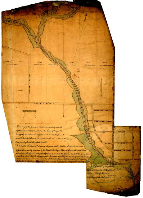
John G. Howard in planning the Lunatic Asylum surveyed the Garrison Creek in the fall of 1845, “in the hope of being able to supply the ... Asylum with water from its sumit [sic] level, but found it could not be done without Pumping therefore preferred the Lake Water.” The ‘Old Garrison’ is at the bottom right. Howard, in his capacity as City Engineer, had recourse to his survey notes again in 1851 when he was asked by Mayor John Bowes to help the Northern [Ontario, Simcoe and Huron] Railroad find a route out of the city, "from below the Market, along the Esplanade and up the Garrison Creek to the summit level above Bloor Street." Bowes was proposing that all railways entering or leaving the west side of Toronto use the ravine as a common corridor [shown as red lines on the plan below]. Provision would be made not only for the Northern line, but for the yet-to-be-built Guelph and Kingston lines as well.
This sketch captures Bowes’ farsighted vision which soon fell victim to the reluctance of the Northern Railway's managers to incur the expense of bridging the creek along the route. They chose instead to build west across the Reserve before turning north beyond Queen Street. Followed later by the Great Western and Grand Trunk Railways, they bestowed on Toronto a planning headache that remains with us even today: pockets of development cut off and isolated by rail corridors. Read here for a detailed account (p2).
Click the map to view a full size version.
Survey of Garrison Creek, 1851 by John G. Howard.
Image courtesy Toronto Public Library: Howard Drawing 737
Next map: 1856 Walkem: Plan Showing [lands] taken by the Toronto & Hamilton (now Great Western) Railway
Back to: The Railways

