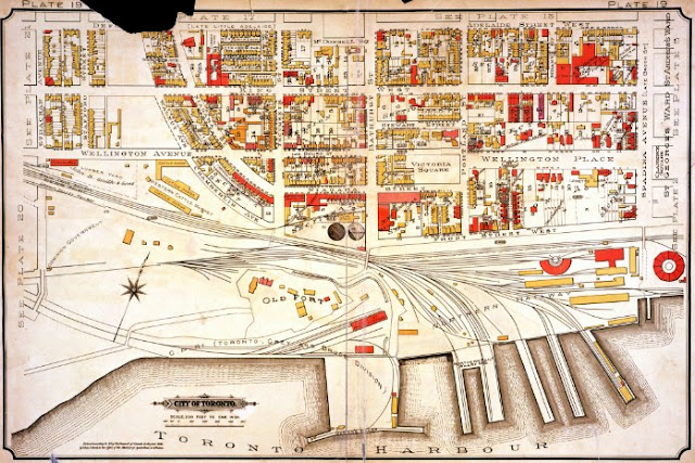
By 1884 the Toronto Grey and Bruce railway, controlled by the Canadian Pacific Railway, had taken over the Queen's Wharf subdivision of the Grand Trunk, although the GTR's cruciform engine house still stood. By 1894 it has been demolished and a freight house had taken its place. A decade later, in 1903, Park Blackwell & Co's. packing house had been built hard on the east end of Fort York; much of the east bastion had been removed in the process.
The 1924 plan in this series was made two short years before the first professional aerial views of Toronto were taken by Fairchild Surveys. The two records compare favorably.
Atlas of the City of Toronto and Vicinity from Special Survey founded on registered plans and showing all building and lot numbers, Plate 19, various editions, by Charles E. Goad, Toronto.
1884. Image courtesy City of Toronto Archives
1894. Image courtesy City of Toronto Archives
1903. Image courtesy Library and Archives Canada, R6990-623-9-E
1913. Image courtesy City of Toronto Archives
1924. Image courtesy City of Toronto Archives
The Goad plates also document several neighboring industrial concerns and land plots meriting scrutiny:
- Western Cattle Market/Municipal Abbatoir/Harris Abattoir (short history here)
- John B. Smith Lumber (more here)
- Stanley Park: named after the Gov. General -- who also lends his moniker to the Stanley Cup and the Stanley Barracks -- this bi-sected parcel survives intact to this day as city parkland
- Patrick Burns Coal Yard / John Doty Machine Works (more here and here)
- Consumers Gas - note the two massive gas holders of 'Station C' of the Consumers Gas Company. Their footprint is still visible on contemporary aerial views. (see above-mentioned 1926 Fairchild aerial)
- Ordnance Triangle lands
- National Casket Co. (Coffin Factory) building
- Robinson cottages (more here, p2)
Next map: 1905 Staples: Proposed New Street Railway Route ... through the Old Fort
Back to: ‘Old’ Fort York


